By Rob Dinwoodie
The summer of ’23 was sweltering hot with no appreciable rain since June, bringing the drought conditions in the Okanagan to their highest. The daytime temperatures had not dropped below 30C for weeks, and everyone was on edge.

British Columbia had declared a State of Emergency due to the wildfires that had impacted communities. It started with Donny Creek, the biggest wildfire the province had witnessed, exceeding 100,000 hectares, and it was only late June. July brought hot weather and more wildfires; Crater Mountain fire saw 50 tourists stranded in a lodge with access cut off; the Osoyoos Fire ran on the dry grasslands and stopped short of the community of Adams Lake. It went on and on.
In late August, I was driving to the south Okanagan to assess an area for Wildfire Risk Reduction (WRR) through Farmland Advantage, a program that the Agriculture Foundation of BC coordinates.
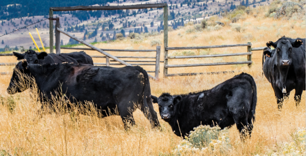
This pilot program is designed to reduce the risk of wildfire on private lands by grazing livestock to remove a portion of the “fine fuels” of grasses, shrubs, and the like to reduce the intensity of a wildfire.
The areas are selected using a Hot Spot GIS mapping tool, assessing risk based on proximity to structures, Agricultural Land Reserve properties, Species at Risk critical habitat, and occurrences.
I was listening to the radio when I heard that a new fire had started from a lightning strike on a mountain west of Kelowna. The weatherman came on and announced that a cold system was coming in; the winds would gust up to 50 km/hour from the south later that afternoon and then shift from the west to the North in early evening.
It was an eerie forecast, knowing the tinder-dry conditions and the many wildfires already burning out of control. This same forecast was also heard 20 years ago when the Okanagan Mountain fire ravaged South Kelowna, burning down 200 homes.

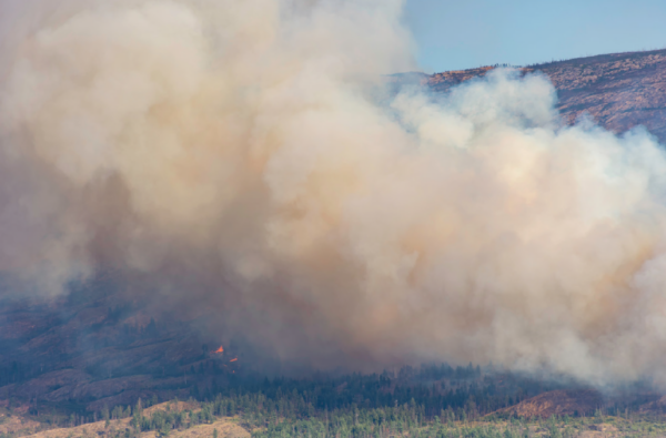
Choking smoke billowing from a wildfire
As forecast, the weather shifted later that afternoon, with brisk winds from the south, fanning the fire west of Kelowna into a raging inferno. The fire was spotting ahead of the flames as the wind and downslope currents brought the wildfire into an area of Kelowna bordering Okanagan Lake.
BC Wildfire Service made valiant efforts as they and the structural firefighters from Kelowna and surrounding communities fought through the night to face what was perhaps one of the most intense firestorms the province had ever witnessed. Throughout that evening and following days, up to 200 structures were lost.
This wasn’t the only fire of note in the province, as most days, over 300 fires were burning, many out of control. Everyone was thankful that September brought cooler temperatures and some precipitation.
In my 30-year career as a Range Officer, I hadn’t witnessed the intensity and size of the wildfires on the landscape within the last decade. I have helped ranchers in the response to wildfires and on the recovery side. The impact of wildfires has changed, and so has the approach to fighting them and looking for ways to prevent them.
There is a very effective Fire Smart program that assists landowners in reducing the risk of wildfire on their properties, but what has been lacking is a larger-scale program of prevention on the bigger landscape. This is where we have seen some headway in BC with the BC Cattlemen’s Targeted Grazing projects, which have looked at using livestock to reduce wildfire threat through reducing fine fuels by livestock grazing and the WRR projects, initiated by Investment Agriculture and Farmland Advantage.
These two programs are coming together to examine how wildfire risk can be reduced when private land and Crown range protect the same community. This is precisely what a project near the community of Lumby in the North Okanagan is designed to do.
Harvesting of timber by Splatsin First Nation within a community forest on rangelands under license to Coldstream Ranch and the managed grazing of private rangelands owned by the same will show how wildfire risk can be achieved using an integrated approach of timber harvest, grass seeding and livestock grazing.

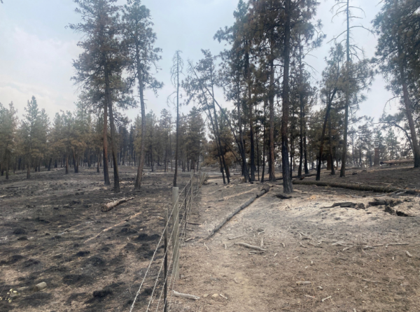
The land to the right of the fenceline has been grazed and this kept the wildfire from getting into the Crowns (tops) of the trees. This was not a targeted grazed site, but this photo shows the result of grazing to reduce a crown wildfire. This allows firefighters an opportunity to fight a fire where otherwise would have to retreat (which is the case with most wildfires where the wildlands intersect with urban dwellings.)
The project is in its early stages, but the outcome looks promising. Reduced tree stocking, grass seeding of cut blocks, and some boundary fencing were required to contain the livestock in a particular area. The site vegetation will determine the extent of livestock grazing in terms of timing and intensity.
Once carrying capacity is understood, a grazing plan and schedule can be developed to ensure the area is not overgrazed. The pastures in areas adjacent to communities are generally smaller, with more intense grazing to achieve a uniform stubble height, which will assist in the event of fire to reduce the intensity.
We know that livestock grazing is only one tool that can be applied to help reduce the risk of wildfire. Thinning, prescribed burning and replanting harvested blocks with fire-resilient species are also ways being assessed to aid in prevention.
It’s early October, and as I travelled to the south Okanagan to assess one of our WRR projects, I heard wildfires are still burning, and the drought is expected to last into next year.
What next year might bring is anyone’s guess, but I can say that using livestock to help reduce risk will no doubt assist in reducing the impact of wildfire.


